Godzilla flattens cities, swats aircraft from the sky, and grows to a monstrous size. No wonder meteorologists have borrowed the name for the tropical Pacific's current warm phase. The US National Oceanic and Atmospheric Administration (NOAA)'s Climate Prediction Centre and the World Meteorological Organization (WMO) both say this event could rank among the strongest since modern monitoring began, potentially surpassing the benchmark El Niño events of 1982-83, 1997-98 and 2015-16.
This matters because this legend isn’t set to simply go down in history: human-caused climate change is warming the oceans. Warmer water evaporates faster, loading the atmosphere with extra moisture and energy that can intensify heavy rainfall, tropical cyclones and other extreme weather when it strikes. All this increases the likelihood of more monstrous weather events in the future. Here we explore the likely global effects and what this means for the UK’s exposure.
What does "Godzilla El Niño" really mean?
El Niño is the warm phase of the El Niño Southern Oscillation, a shift in sea surface temperatures and winds across the equatorial Pacific that reshapes rainfall and storm patterns worldwide.
"Godzilla" is journalistic shorthand, not a scientific classification, first used during the 1997-98 event, then again in 2015-16, for events too severe to be labelled merely "strong."
The 2026-27 event earns the label due to the numbers. The WMO confirmed its development in early June, and by September, UN Secretary-General António Guterres was describing it as "supersizing before our eyes." NOAA's Relative Oceanic Niño Index puts the central equatorial Pacific anomaly at roughly 2.7°C, within range of the strongest El Niño events on record.
So what are the odds that this Godzilla could claim the title of most ferocious ever recorded? Columbia University's International Research Institute for Climate and Society puts the odds at 100% through February 2027, easing to 97% by May, and NOAA's Climate Prediction Center puts the odds above 90%, with roughly a 75% chance of exceeding the threshold for one of the strongest events on record.
Signs are already showing: on 22 August, the Copernicus Climate Change Service logged a record global sea surface temperature of 21.10°C, in line with 2026 running on track to be the second-warmest year on record, with some forecasters flagging 2027 as more likely to set an outright new high.
The atmosphere is already responding to the exceptionally warm ocean waters: convection and rainfall have intensified across the central and eastern Pacific.
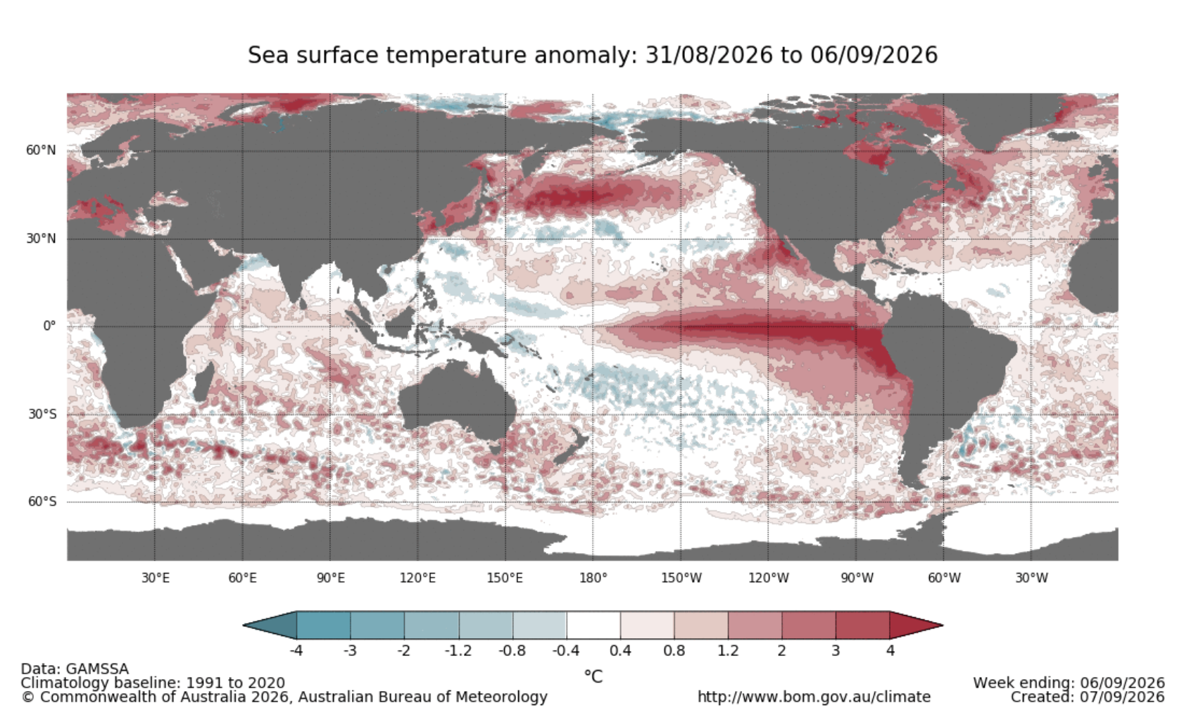
Sea surface temperature anomalies for the week ending 6 September 2026. The warm anomalies (red) stretching across the equatorial Pacific are the signature of the ongoing El Niño event. Source: Australian Bureau of Meteorology.
Yet none of that guarantees a repeat of 1997-98 or 2015-16, region for region. Dr Mandy Freund at the University of Melbourne puts a useful disclaimer: "El Niño is a risk factor, not a forecast." Some of the strongest events on record still delivered near-average rainfall across large parts of Australia. Strength raises the odds of extremes. Where those extremes land is a separate question, and one this event hasn't fully answered yet.
What will the likely impacts be?
Based on historic data from 1982–83, 1997-98 and 2015–16 we can expect:
1. Water in the wrong places
During the 2015-16 event, extreme rainfall and flash flooding hit Louisiana, Texas, Arkansas and Mississippi, causing billions of dollars in losses in March 2016 alone. That December, storms, tornadoes and flooding killed roughly 50 people across the central and southern US, including Texas and Mississippi, after the US East Coast had already seen extreme rainfall the previous October, concentrated in South Carolina.
2. Disrupted shipping routes
El Niño-driven drought has lowered water levels in the lake that feeds the Panama Canal, and the Canal Authority is responding by cutting capacity: daily transit slots dropped from 36 to 34 on 3 September, and to 32 on 15 September. On 11 August, one container ship carrying 10,100 containers paid $4 million to skip the queue rather than face a wait running well over a week. That single payment is a rough proxy for what a bottleneck like this does to freight costs across a season.
El Niño's warmer waters are also fuelling a livelier typhoon season across East Asia. Five typhoons, Bavi, Dolphin, Narra, Peilou and Chan-Hom, made landfall within a single fortnight, and Maersk has confirmed that all 14 of the region's busiest ports are now seeing reduced on-time vessel arrivals. The carrier is advising customers to build in buffer time and consider air freight or inland storage for time-sensitive cargo. These disruptions are landing on a global economy already under strain from wars, trade disputes and rising commodity costs, and you don't need Pacific-facing suppliers to feel them.
3. Widespread hunger
The UN's Food and Agriculture Organisation and World Food Programme issued a joint appeal on 18 June targeting 8.8 million people across 22 high-risk countries for anticipatory funding. The UN has separately warned that up to 49 million people worldwide could be pushed into acute hunger this cycle. The African Development Bank projects a 1 to 2% GDP reduction across the hardest-hit African economies, an estimated $10 to $20 billion in total, with associated migration pressures continuing to rise..
At sea, NASA's PACE satellite has recorded a sharp decline in phytoplankton in the affected waters, with effects moving up the food chain to fish, marine mammals and seabirds (we recommend trying the ‘chlorophyll curtain’ in this article to visualise the impact on ocean ecosystems), triggering challenges for fisheries, fish farming and food production worldwide.
The UK's indirect exposure
Direct effects on British weather are hard to forecast this far out and typically lag the event by months, though forecasters are flagging a higher chance of extreme winter weather in 2027. The sharper risk runs through trade: crop losses and shipping disruption abroad feed into UK food prices and availability, a link flagged in a House of Commons Library briefing on the event. For scale, the 1998 El Niño is credited with record heat, thousands of deaths worldwide and tens of billions of dollars in economic damage. This one is forecast to run warmer.
You have come to the place for thought leadership.